
For several days now, the air has been clear from Chillán to La Araucanía.
The smoke has dissipated, foreign firefighters have returned to their countries, and the Ten Tanker has flown to new horizons. The 2023 summer fires, which will be remembered as the deadliest in recent decades, have already faded into the corners of the web and television screens. However, the only thing that ended was the fire itself.
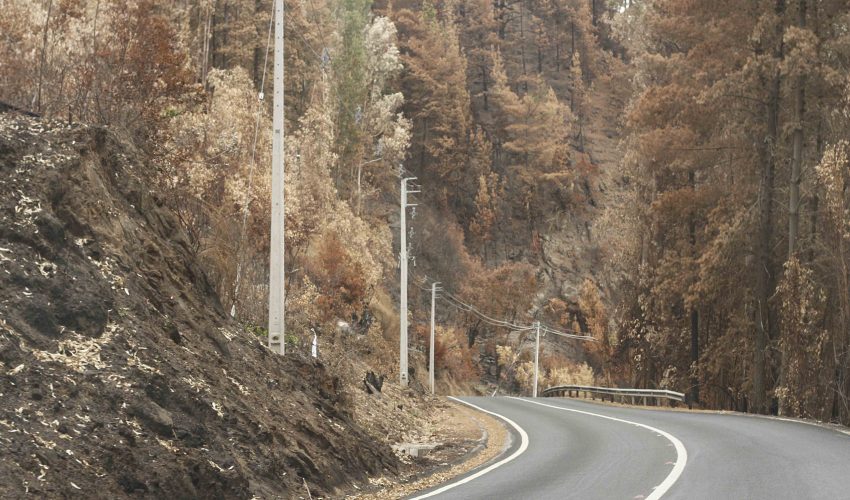
The fires are still there and will remain in the lives of thousands of people. Today, it is a destructive scar, but in early February, it was a hell that swept away everything in its path across more than 305,869 hectares in the three regions.
Of that area, 200,824 hectares correspond to pine and eucalyptus plantations destined for the forestry industry. These figures come from analyses conducted by the Landscape Ecology Laboratory of the University of Concepción (Lep UdeC).
To achieve this, satellite images from Sentinel were used, along with various variables to produce revealing and unfortunately brutal maps of the burned territories in communes like Tomé, Santa Juana, and Nacimiento, to name just a few of the most affected.
Variables The Lep UdeC conducted research in December 2022, which identified Penco, Tomé, Concepción, Santa Juana, and Hualqui as the communes most prone to wildfires.
This time, satellite images with a 10-meter resolution were used to determine the degrees and severity of the fires, resulting in devastating numbers: in Ñuble, 49,644 hectares burned; in Biobío, 147,691; and in La Araucanía Region, over 94,461.86.
What follows is a ranking of the three most affected communes in terms of area—a grim exercise not only because of the numbers but also due to all the facets involved in such a tragedy. Santa Juana has 42,858.97 hectares burned, equivalent to 55.14% of its communal area. Next is Nacimiento, with 32,037.98 hectares (35.14% of the commune), followed by Tomé, with 18,500.36 hectares (37.34% of its communal area). Adding Mulchén, these represent 75% of all fires in the Biobío Region. Severity is another aspect of the diagnosis. "With this variable, we assess the damage to vegetation caused by wildfires. This index is calculated using satellite images taken immediately before and after the fire. The difference in the energy reflected by the vegetation before and after the fire allows us to evaluate the severity levels of the impact," explains Rodrigo Fuentes Robles, a researcher at Lep UdeC.
The "Ruta de la Madera" (Timber Route), connecting the Biobío Region with La Araucanía along the eastern side of the Nahuelbuta Mountain Range, is now a sad open-air classroom for understanding the painful factor of severity and its impact on the land. From Santa Juana to Nacimiento, vast areas were left with nothing spared by the fire, except for a few homes where residents had to fight a fierce battle against the flames at close range.
"Simply put, high to very high severity means complete charring of the cover (foliage, branches, and trunks). In contrast, low to intermediate severity will show damage only to the foliage of trees or shrubs affected by the fire," adds the researcher.
Types of Land Cover
To calculate the different land covers affected by the fires, satellite images with a 30-meter resolution were used.
These covers range from native forests to forest plantations, agricultural lands, shrublands, and grasslands, among others. Thus, among the conclusions reached by Lep UdeC researchers, it was identified that large areas with monoculture plantations were the most devastated by the fires. At the regional level, considering this land cover variable, Biobío has 116,145 hectares burned with industrial plantations out of a total of 154,000; La Araucanía has 52,014.42, and Ñuble, 32,664.69.
Regarding native forests affected by the fires, the numbers differ: in Biobío, 7,934 hectares burned; in La Araucanía, 5,236; and in Ñuble, 1,440 hectares. These figures reveal a common denominator in vast landscapes, warns Dr. Cristian Echeverría Leal, academic and director of Lep UdeC.
"Currently, in central and southern Chile, there are vast areas of forest plantations with exotic species, some forming continuous units of nearly 300,000 hectares, stretching uninterrupted over 180 km from one region to another. It is these types of landscapes that have been subjected to the latest mega-fires."
In Biobío, 76% of the land affected by fire corresponds to forest plantations, 5% to native forests, 10% to shrublands, and 9% to agricultural crops and grasslands. The Santa Ana fire, which covered Santa Juana and Nacimiento, burned 85,801 hectares, while El Cortijo ravaged over 24,300 hectares, from Florida to Tomé.
In all these communes, the misfortunes unfortunately do not end; beyond the destruction, areas susceptible to mass removal (landslides and collapses) exceed 39,000 hectares.
The word that accompanies the tragedy is reconstruction.
In this sense, in a context of climate change and drought, the territory is at permanent risk, explains the University of Concepción academic. "Restoring landscapes—a process aimed at recovering ecological integrity and the landscape's ability to provide essential ecosystem services for human well-being—must be done in a way that reduces the vulnerability of territories to wildfire risks, among others."
Additionally, he emphasizes the importance of maintaining heterogeneous landscapes—a mosaic of natural and modified ecosystems—because this allows for varying vegetation fuel loads and diverse environmental conditions. "Let us remember that even before the fires, the degradation of these territories was far from a sustainable trajectory, with landscapes subjected to intensive land use by the forestry industry. In other words, we cannot restore the landscape to its state the day before the fire but must move toward a new, multifunctional, and less vulnerable landscape," adds the director of Lep UdeC.
Source:www.diarioconcepcion.cl


Comments (0)
No comments yet. Be the first to comment!
Leave a comment