
The closing seminar of the EcoLidar project, held in early November 2025, served as the platform to present the results and lessons learned from the LiDAR Prototype for Forest Inventories in Native Forests of Aysén. This project represents a significant advancement in the sustainable management of forests, with a special focus on the evergreen and lenga forest types.
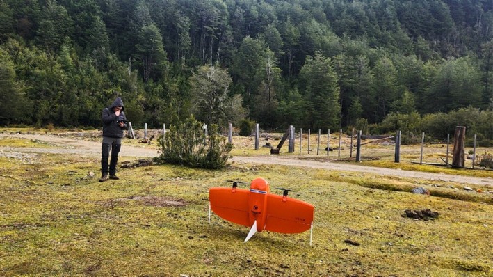
LiDAR technology, which involves light detection and ranging, enables measuring distances with unprecedented precision, creating three-dimensional models of the environment. Equipped on high-end drones, these sensors have provided detailed data on vegetation height, terrain, and condition, even in hard-to-reach areas.
José Luis Pérez Vargas, provincial head of CONAF Coyhaique, has emphasized the importance of this innovation, which complements forest management tasks and the recovery of degraded forests. According to Pérez Vargas, EcoLidar's technological tools enhance the understanding of the landscape and the ecosystem services that forests provide to the region.
Andrés Gómez Hernández, Agricultural Engineer and technical manager of AgroPlan Limitada, explained that land management in Aysén requires accurate information for effective land use planning and native forest management. LiDAR sensors have enabled the collection of continuous and detailed data, facilitating planning and reducing risks and costs.
The preliminary results of the project are promising. The technical team has managed to reduce the time required for data collection to just 700 hectares per day under ideal conditions, and subsequent processing takes only two working days for properties of up to 550 hectares.
Elizardo Aguilar Retamal, a local producer, shared his experience with the project, highlighting the speed and utility of LiDAR technology in planning his 260-hectare property. The implementation of this technology has enabled land organization in a matter of hours, instead of a month, and facilitated long-term planning for more orderly and responsible field management.
The integration of the obtained information with GIS systems and geospatial analysis tools has improved forest planning and visualization capabilities. Furthermore, the EcoLidar project, awarded in 2024, is projected to lay the groundwork for replicating this technology in other areas of the country, with an expected closure in November 2025.
This project not only demonstrates the feasibility of combining science and technology for environmental conservation but also underscores the Aysén Region's commitment to sustainability and the responsible use of its forest resources, ensuring biodiversity and productivity for future generations.


Comentarios (0)
No hay comentarios aún. ¡Sé el primero en comentar!
Deja un comentario