
A positive record amounting to 3,442 hectares of native forest was established in the recent update of the Vegetation Resources and Land Use Survey for the Los Ríos Region, covering the period between 2017-2024. This figure includes the growth of natural stands and cartographic adjustments to describe forest use according to Law 20.283.
According to the study conducted by the National Forestry Corporation in 2017, the sub-use of native forest amounted to 935,968 hectares, while in 2024 it reached 938,458. This difference of 3,442 hectares accounts for changes in growth but is mainly due to cartographic adjustments, recovering forest units not previously monitored due to the scale of work.
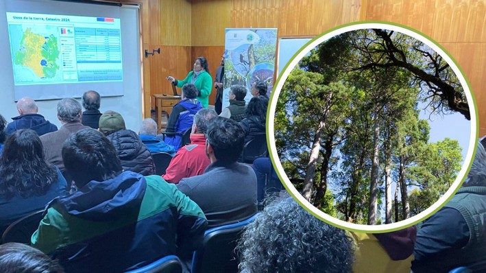
The figures were presented in Valdivia by CONAF at the headquarters of Infor (Forestry Institute), before authorities, researchers, groups, public services, and forestry consultants.
For Arnoldo Shibar, regional director of CONAF Los Ríos, "this information is key for our region, as it allows public services to make informed decisions and incorporate them into their plans, programs, and policies; and at the same time, it provides relevant input for researchers to generate new findings on the development of our forests."
Updated Information
Francoise Pincheira, head of the Monitoring Department of CONAF's Forest Enforcement and Environmental Assessment Management, stated that "today the region has more updated information and a better description, not only of the forest but also of other resources, such as wetlands and shrublands."
For this survey of the Los Ríos Region, the areas associated with each land use, the distribution of vegetation ecosystems, and their forest types were reviewed. Thus, 63.4% of the regional surface is covered by forests (51.1% with native forest, 11.67% with plantations, and 0.6% with mixed forest). Other uses corresponding to agricultural lands occupy 18.3%, and grasslands and shrublands account for 7.9% of the regional surface.
The monitoring also indicates that the most extensive area is centered on forest ecosystems, with a total of 1,163,546.4 hectares (938,458.7 of native forest, 214,236.7 of plantations, and 10,824.0 of mixed forest). Meanwhile, agricultural lands reach 336,483.9 hectares, and grasslands and shrublands record 144,406.7 (an area that includes grasslands with 78,493.8 ha, followed by shrubland with 41,369.2 ha). On the other hand, water bodies cover 109,855.8 hectares, while urban and industrial areas cover 12,060 ha.
This work was developed jointly by professionals from CONAF and the Faculty of Forest Sciences and Vegetation Resources of the Austral University (UACh), under the direction of Guillermo Trincado.
Óscar Thiers, dean of the Faculty of Forest Sciences and Natural Resources of UACh, highlighted that the university has been leading this survey of Chile for two decades, "an effort that has not only contributed baseline and updated information for decision-making in territorial planning, forest resource management, conservation, and natural resource management but has also strengthened our university mission in three key dimensions: teaching, research, and community engagement and regional commitment."
Supplementary Information
In this regional update, ten of the twelve forest types comprising the entire native forest area were identified. These are: alerce, ciprés de las Guaitecas, ciprés de cordillera, araucaria, lenga, coihue de Magallanes, roble-raulí-coihue, coihue-raulí-tepa, esclerófilo, and siempreverde (Chilean palm and roble-hualo are absent in the region).
The roble-raulí-coihue is the most extensive forest type, with a coverage of 275,400.7 hectares (29.4% of the total regional native forest). It is followed by coihue-raulí-tepa with 275,067.2 (29.3%). Lenga covers an area of 151,946.4 hectares (16.2%), and the araucaria forest type covers 13,893.4 (1.48%).
Additionally, three species in conservation categories were detected: araucaria (Araucaria araucana), alerce (Fitzroya cupressoides), and planta del león (Valdivia gayana).
Finally, when reviewing the land use change figures, it was determined that during the period from 2017 to 2024, 1,928 hectares of native forest were lost, with the main causes identified as: the conversion of 671 hectares for agricultural or livestock land development, 115 ha due to changes caused by large-scale forest fires, 95 ha due to urban growth and infrastructure, construction of industrial-mining areas, civil works, 42 ha due to substitution, and 1,005 hectares of native forest were converted to other land uses for reasons not determined by this study.


Comments (0)
No comments yet. Be the first to comment!
Leave a comment