
During times of higher risk for forest fire occurrence, the preventive management of vegetation in areas where power grids and vegetation interact is essential to create safety buffers and prevent incidents that affect the energy supply.
The University of Concepción, through interdisciplinary work integrating expertise in electrical engineering, forest sciences, and spatial analysis, developed an innovative methodology for preventing forest fires and protecting the energy supply, by creating risk maps for areas where vegetation and power lines interact.
This initiative is part of a technical assistance project carried out for the distribution company Coelcha, which operates primarily in rural areas of the Ñuble and Biobío regions.
A team composed of academics Luis García Santander and David González Lanteri, and forestry engineer Bastián Rivas Maldonado, established a highly reliable methodology for creating risk maps in areas of contact between power lines and vegetation.
The tool—developed based on satellite images, active sensors, and cameras—becomes a key input for preventing incidents on transmission lines during the forest fire season and also when frontal systems occur.
The problem of interaction between vegetation cover and the distribution company's infrastructure was addressed progressively, in two complementary stages, with the participation of electrical, forestry, and geomatics engineers.
"This integrated approach has been key to simultaneously addressing the technical requirements of the power grid and the structural and dynamic characteristics of the vegetation," said David González Lanteri, professor from the Department of Forest Management and Environment of the Faculty of Forest Sciences (FCF) at UdeC.
Vegetation Cover Classification
In a first phase, in 2024, a study was conducted to classify the type of existing vegetation cover along the easement strip that runs parallel to the medium and low voltage power lines.
Luis García Santander, professor from the Department of Electrical Engineering of the Faculty of Engineering and a specialist in energy efficiency and smart grids, stated that the objective was to identify and quantify areas of the power lines affected by any type of plant.
To achieve this, they used vegetation reflectance techniques at different wavelengths, based on high-resolution satellite images.
"With this methodology, we managed to classify herbaceous, shrub, and tree covers with reliability levels above 95%," indicated David González, who is a specialist in remote sensing and spatial analysis.
Dr. García Santander explained that processing the information allowed for generating a priority map of areas with lesser or greater vegetation presence according to the given classifications, which also serves to estimate the costs associated with preventive pruning, clearing, and/or thinning programs in those areas.
"However, from the beginning it was evident that the main operational problem for the company was not only identifying the type of vegetation cover, but objectively and with high precision knowing its height," detailed González.
LiDAR Technology
This is how the UdeC specialists moved to a second stage, complementing the initial work with LiDAR remote sensing sensors (from English Light Detection and Ranging) carried by drones, which were previously tested to determine their accuracy in estimating vegetation canopy height.
"The results of this validation were positive, obtaining mean errors close to ±40 cm in determining vegetation height using LiDAR technology, which proved fully acceptable and suitable for the project's objectives," explained the FCF academic.
In addition to the sensors, RGB cameras with a resolution level close to two centimeters were used.
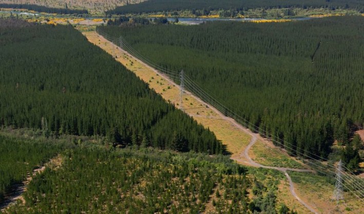
In this way, it was possible to work with very high spatial resolutions, generating a large amount of data in the power line easement strip, which is 36 meters wide.
From this data, and using R programming, detailed information about the vegetation present in the easement line was generated.
"The analysis is conducted meter by meter along the longitudinal path of the power line and, transversely, for each meter of lateral advance, identifying the existing type of vegetation and its height relative to the underlying terrain," indicated González.
Greater Precision
With this new project, it is possible to evaluate the state of vegetation with greater precision, both within the safety buffer and outside it, "but which, due to its height, could project a fall onto the power lines," said García Santander.
"Identifying these vegetation/power line risk zones allows for initially reducing supply cuts due to falling trees or branches on power grids and also the start of forest fires, whether by rubbing/contact between vegetation and energized lines," specified the Engineering professor.
The large volume of data initially obtained through this tool is later transformed into useful information for decision-making within the company.
Thus, commented Dr. González, it is possible to know precisely where vegetation exists, how much there is, and how critical it is within the easement strip based on its height and position.
"This allows prioritizing interventions, optimizing resources, and reducing risks associated with the interaction between vegetation, power lines, and forest fires," he emphasized.
According to García Santander, this type of work is an example of companies' increased concern regarding potential incidents linked to their facilities.
"Due to the increase in storms and forest fires in recent years, mainly due to climate change, coupled with the high standards established by bodies such as the Superintendency of Electricity and Fuels and the Ministry of Energy, companies are interested in improving their pruning/clearing/felling plans and programs for each period," asserted the researcher.
Source:UdeC News

Comments (0)
No comments yet. Be the first to comment!
Leave a comment