
The Forestry Institute (Infor) delivered a preliminary report, prepared based on the delimitation of areas affected by fires provided by CONAF, corresponding to the period from February 1 to March 9, 2023, between the Metropolitan and Los Ríos regions.
As sources of information, the Land Use and Vegetation Survey and the generation of fire-affected polygons, both from CONAF, were used, along with the Forest Plantation Update Program generated and managed by INFOR, which refers to standing plantation areas.
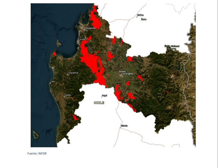
Report prepared with information on relevant forest fires, from February 1 to March 9, generated by CONAF, covering 398,817 hectares. Of this area, the Biobío region accounts for 49% of the total, followed by the La Araucanía region with 28% and Ñuble with 16%. Of the total area affected by fires, 76% corresponds to tree-covered land (native and exotic), 14% to agricultural land, and 9% to grasslands and shrublands.
This classification is used in INFOR's future timber availability studies and categorizes the owner according to
the area of forest plantations that constitute their assets, as indicated below:
• Large companies: over 30,000 hectares
• Medium-sized companies: between 5,000 and 30,000 hectares
• Medium owners: between 200 and 5,000 hectares
• Small owners: less than 200 hectares.
Additionally, the report includes information on the number of small and medium owners affected by burned plantation areas. The number of owners was estimated by CIREN using CIREN's property layers, grouped by Region, Province, and Municipality, based on the fire-affected plantation polygons of small and medium owners generated by INFOR. Note that these figures are only estimates, and the update years of the layers are as follows: Maule: 2021; Ñuble/Biobío: 2016 (the regions had not yet been divided); Los Ríos: 2019; and La Araucanía: 2012. The number of owners was not estimated for the Metropolitan and O'Higgins regions.


Comments (0)
No comments yet. Be the first to comment!
Leave a comment