

Canada has one of the most extensive forest heritages on the planet. More than 360 million hectares of forest sustain a forest-industry sector that contributes over $30 billion to the national GDP, captures carbon, and preserves much of the Northern Hemisphere's biodiversity. That heritage coexists with a threat that worsens year after year. Each fire season, flames consume an average of 2.8 million hectares of Canadian forest, a figure that in years of extreme conditions can double or triple. And those conditions are becoming increasingly frequent. In 2023, more than 18 million hectares burned across the territory, shattering all national and regional records.
The 2024 season, though less catastrophic, added another 5.3 million hectares—nearly double the historical average—and 2025 is already shaping up as the second-worst season on record, with more than 7.3 million hectares consumed by fire. Quebec, in the francophone north, was among the hardest-hit regions.
After a high-intensity fire, the forest does not regrow immediately. Soil conditions, the loss of the seed bank, and the extent of affected areas often make natural regeneration slow, insufficient, or outright impossible without human intervention. Conventional restoration methods—manual planting, aerial seeding with small planes or helicopters—face severe logistical hurdles. Much of the burned area lies in remote or hard-to-reach zones, where mobilizing planting crews is costly and complex. The work window is short, and seasonal labor is increasingly scarce. In that bottleneck, FPInnovations seeks to innovate with new reforestation strategies.
Seeding that comes from the air
FPInnovations is a private, non-profit organization dedicated to research and development applied to Canada's forestry sector, with laboratories in Montreal and Quebec City. Its mission is to sustain the competitiveness of the timber industry through technological innovation. Along those lines, it launched a field trial program to assess the potential of drone-based aerial seeding as a complement to traditional reforestation methods. The project is funded by Quebec's Ministry of Natural Resources and Forests (MRNF, by its French acronym), the provincial agency responsible for forest land management and public forest restoration policies.
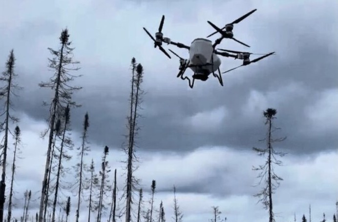
During the boreal spring of 2026, FPInnovations deployed various drone systems in the field to validate several aspects of the approach, including their real operational capacity, the accuracy of remote sensing technologies for identifying the most suitable seeding sites, and the germination performance of different capsules and seeds.
The technique replaces manual planting work with unmanned aerial vehicles that disperse seeds over the burned ground. Instead of dropping them loose from height, as happens with helicopter or airplane seeding, this system uses biodegradable capsules containing the seed along with water, nutrients, and, in some cases, beneficial fungi that improve the chances of the plant thriving in the nutrient-poor soils left by fire.
The most advanced systems employ RTK (Real-Time Kinematic) technology to improve seed placement accuracy and reduce overlap and waste. Conventional aerial seeding protocols distribute seeds uniformly across the entire area to be reforested, which raises seed demand, since a good portion ends up in sites where conditions do not favor germination. The latest research lines point toward precision seeding, targeted at specific microsites within the burned terrain, capable of reducing seed consumption per hectare and increasing establishment rates.
According to industry estimates, drone seeding can cut operational costs by up to 80% compared to manual methods, although those figures still depend on variables such as terrain type, tree species, and the effective survival rate of seedlings.
What is being measured
The trials conducted in the boreal spring of 2026 cover three dimensions of analysis. The first is operational: verifying whether the drone systems available on the market have the flight capacity, autonomy, and stability needed to operate in real forest conditions, with variable wind, uneven vegetation, and significant distances from loading points.
The second dimension involves remote sensing technologies, that is, the use of remote sensors to accurately identify the most suitable seeding zones within a burned area. Not all of the surface affected by a fire has the same soil, moisture, and sun exposure conditions, and directing seeding toward sites with the highest germination probability is decisive for the method's efficiency.
The third variable is the seed itself. The project evaluates different types of capsules and formulations to protect the seed during aerial dispersal and improve its contact with the soil. A seed dropped from height over uneven terrain can end up on rock, under a thick layer of ash, or exposed to conditions that prevent germination. The capsules aim to offset that randomness and increase the establishment rate per seeded unit.
The project is carried out in collaboration with governmental, academic, and industrial partners, whose participation allows results to be compared across different ecological and regional conditions.
Next steps
FPInnovations plans to release the study's preliminary results in the boreal autumn of 2026. Those initial data will allow for evaluating the germination performance recorded in the spring trials, the effective accuracy of remote sensing for site selection, and a first cost estimate compared to conventional methods.
Source:Bioeconomia



Comments (0)
No comments yet. Be the first to comment!
Leave a comment