
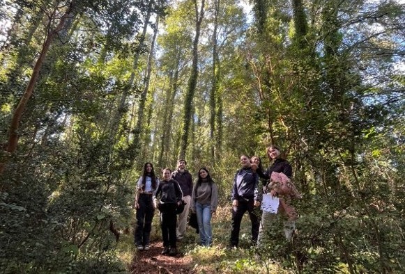
The Arboretum and Fundo Teja Norte were the properties where Forestry Engineering students from Universidad Austral de Chile approached different dimensions of territorial planning and management. These were two field trips within the framework of the "Territorial Planning" course, whose purpose was for future professionals to be able to understand and manage the complexity of territories, as well as to identify elements and attributes susceptible to being represented cartographically for the development of a territorial diagnosis.
According to the UACh professor in charge of the course, Nolwenn Boucher, during the tour the participants observed environmental components, infrastructure, land use, and areas of interest for conservation and the development of academic and recreational activities.
"Based on the information collected in the field and complemented with spatial analysis tools, the students created thematic maps and technical reports that included diagnoses and recommendations aimed at a potential territorial management plan for the sector. This exercise allowed them to apply territorial analysis methodologies and strengthen skills related to the interpretation and representation of geographic information," explained the professor.
A Living Laboratory
For the students, field activities like this are of great value for their training. "As a 5th-year forestry engineering student, year after year I have had to go to this sector in different courses, which provides different points of view of this place. Knowing this space from the perspective of territorial planning and how society sees it, I think it is unfortunate, since being a place that provides different services, it is not used as it should be," commented student María Jesús Estobar.
The student recounted that during the session, there was discussion about the use given to this site and the delimitation of the property, in addition to the problem of pets and cyclists entering, which is exacerbated by the scarce delimitation and signage of the appropriate routes for these purposes. "There are records of different birds and snakes being run over by those cycling. Alternatives that could mitigate this were discussed so that the population recognizes that this living laboratory is very important for the entire community," she emphasized.
Visit to the Environmental Assessment Service
As a complement to this experience, the students also participated in a visit to the Environmental Assessment Service (SEA) of Valdivia. On the occasion, the regional director of the SEA, Guillermo Ready, was present, along with professionals from the institution, who presented the functioning of the organization and the Environmental Impact Assessment System (SEIA), addressing the main stages of the environmental assessment process, citizen participation, and coordination among public agencies.
One of the students who attended was Vanessa Hernández, who emphasized that "it is important for us to participate in these instances to have a closeness to these agencies that require planning tools to learn firsthand how they are managed, what the sectoral needs are, and what the main challenges are that institutions face in fulfilling their objectives and functions."
"We learned that the SEA participates within environmental legislation in the project evaluation stage, under the guidelines of Article 81 of Law 19,300 on General Bases of the Environment, which provides the guidelines for its operation. The function of this agency is to evaluate whether projects should enter the evaluation system or not, and when they qualify to enter, it is responsible for reviewing the Environmental Impact Studies (EIA). Additionally, it leads a consultation process with the project's owner entity until its approval or rejection," she added.
This visit generated a conversation that addressed real situations of environmental management and territorial decision-making. An example of this was the topic of the Regional Territorial Planning Plan, responsible for guiding the sustainable development of the territory, a very important area in relation to environmental impact studies and communities.
These instances strengthen the capacity of future professionals to understand the complexity of territories, integrate multiple dimensions in decision-making, and contribute to the design of strategies for planning, conservation, and sustainable development, aspects that are increasingly relevant in the practice of the forestry profession.


Comments (0)
No comments yet. Be the first to comment!
Leave a comment