

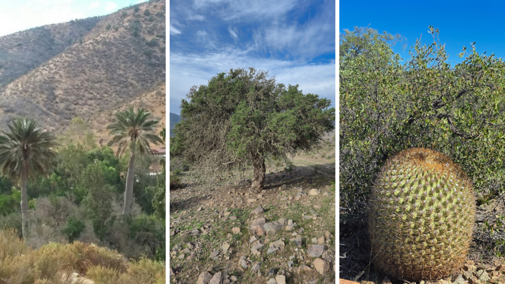
The update of the Vegetation Resources and Land Use Inventory of the Coquimbo Region made it possible to have more precise cartography on the areas associated with the different land uses, as well as on the distribution of forests and their respective forest types. In this update, 467 dominant species were identified, 12 of them not recorded in the previous inventory. Likewise, three forest types were determined that comprise all of the region's native forest: Sclerophyllous, Chilean palm, and Evergreen.
The inventory covers an area of 4,059,716 hectares. Among the main land uses are grasslands and shrublands, which represent 71.6% of the region (2,906,590 ha); areas devoid of vegetation, which correspond to 18.8% (762,060 ha) and include high peaks, river beds, and lands located above the altitudinal limit; and forests, which represent 3.7% of the regional area (152,983 ha). The remaining percentage corresponds to other uses, including agricultural lands, urban and industrial areas, and wetlands. Within the Forest category, 138,324 hectares (3.4% of the regional area) correspond to native forest, 12,472 hectares (0.3%) to forest plantations, and 2,188 hectares to mixed forests.
CONAF's deputy executive director, Juan Carlos Castillo, explained that the previous monitoring had been published more than a decade ago, so it was necessary and expected to have updated cartography, with greater precision and a high level of territorial detail. In the monitoring carried out in 2014, approximately 48,000 hectares of native forest were recorded, while the update corresponding to 2025 records more than 138,000 hectares. CONAF specifies that this difference responds to a cartographic adjustment, resulting from greater field validation and improvements in the processes of photointerpretation and description of the areas, especially in sectors that had not been identified in the previous cartography.
Same methodology, new technological tools
The methodology used for the preparation of the inventory remains the same. The main difference lies in the technology used for its application, which made it possible to identify native vegetation formations with greater precision. Added to this advance was a greater institutional deployment by CONAF, which included new field verification campaigns for information gathering, as well as the incorporation of georeferenced and standardized institutional inputs.
In this update, three forest types are described. The Sclerophyllous type is the predominant one, with 137,035 hectares. Within this type, the Peumo-Quillay-Litre subtypes stand out, with 85,161.8 hectares, and Sclerophyllous, with 31,909.5 hectares. Likewise, the Chilean palm forest type is recorded, with 1,047 hectares, and the Evergreen forest type, with 242 hectares, represented by cloud forests or coastal olivillo forests located in Fray Jorge National Park.
In the Choapa province, an area with dominance of the emblematic Chilean palm species (Jubaea chilensis) was verified and incorporated, located north and south of Tilama, in the direction of the Las Palmas Tunnel, and north of the Culimo reservoir. These palms have been historically present in the territory. What changes with this update of the inventory is that their presence was identified, delimited, and quantified systematically.
The update also made it possible to detect a greater area of formations of ecological and preservation importance, among them those associated with Chilean algarrobo (Prosopis chilensis), guayacán (Porlieria chilensis), chañar (Geoffroea decorticans), and carbonillo (Cordia decandra). An important part of these plant formations was complemented through analysis and data obtained during various field campaigns carried out in the region.
The head of CONAF's Monitoring Department, Francoise Pincheira, highlighted that this update makes it possible to know land uses with greater precision, identify the area of forests and vegetation, and establish a basis for quantifying regional ecosystem services, among them wood production, soil protection, carbon capture, wildlife habitat, and recreation. "This information constitutes a relevant input to support decision-making in matters of territorial management and planning, as well as to contribute to climate change mitigation," she explained.


Comments (0)
No comments yet. Be the first to comment!
Leave a comment